 Tweet
Tweet
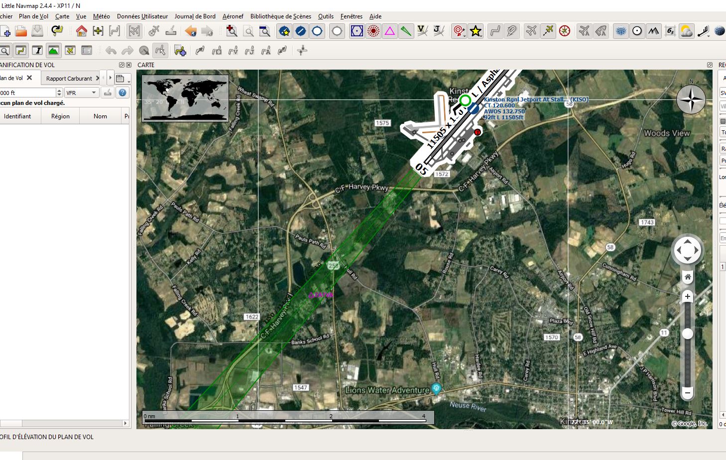
Dans la męme veine qu'Ortho4XP et la carte IGN- OACI je me demandais si on pouvait avoir la carte IGN-OACI avec Littlenavmap
exemple dgml : google - > url_template=http://mt{switch:0,1,2,3}.google.com/vt/lyrs=s&x={x}&y={y}&z={zoom}
essayer avec IGN-OACI -> url_template=http://wxs.ign.fr/an7nvfzojv5wa96dsga5nk8w/geoportail/wmts?&SERVICE=WMTS&VERSION=1.0.0&REQUEST=GetTile&L AYER=GEOGRAPHICALGRIDSYSTEMS.MAPS.SCAN-OACI&STYLE=normal&tilematrixset=PM&Service=WMTS&Re quest=GetTile&Version=1.0.0&Format=image%2Fjpeg&TI LEMATRIX={zoom}&TILEROW={y}&TILECOL={x}
Pour l'instant je cale
une idée ?
Le dgml OACI-IGN que j'essaye de créer.
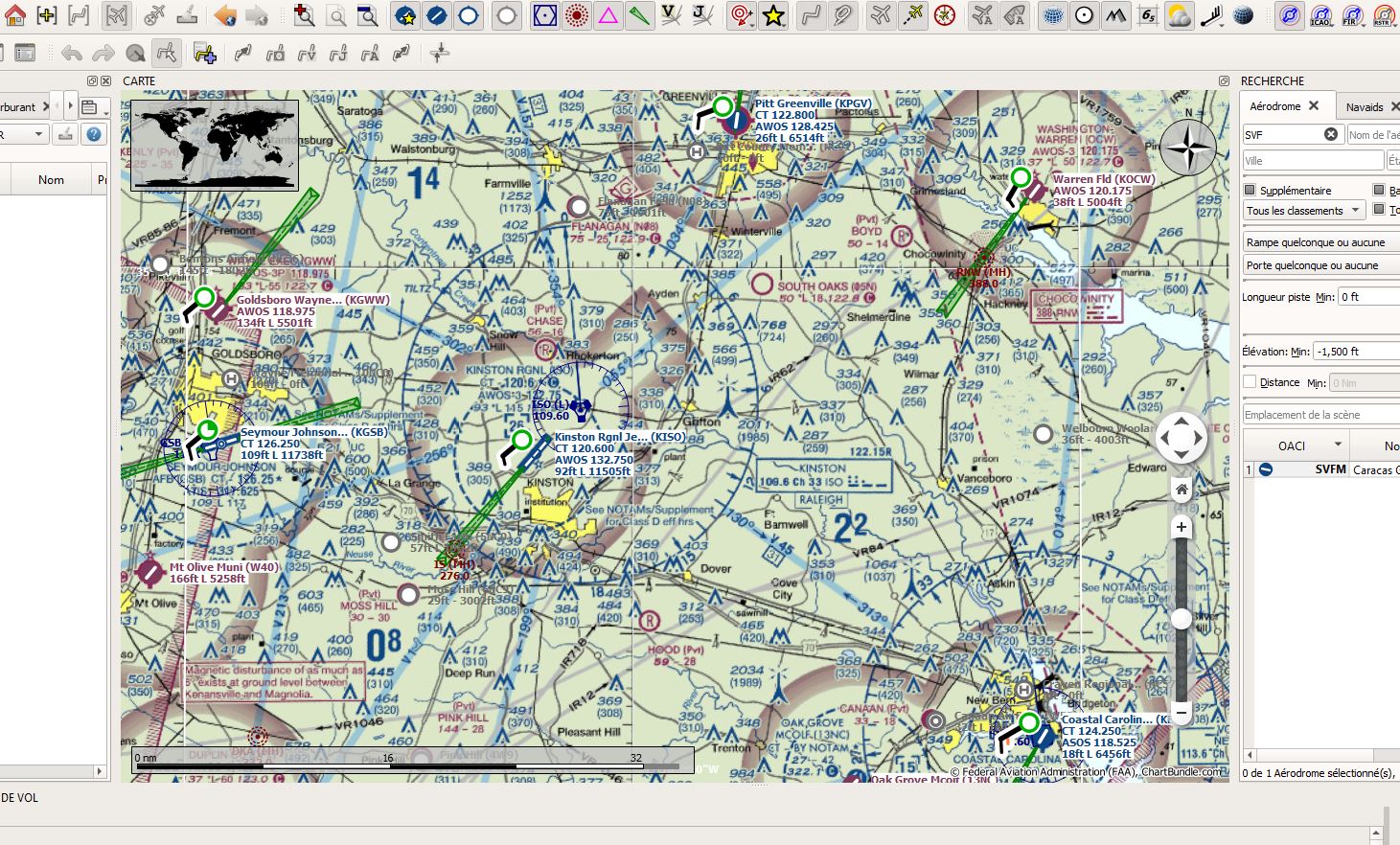
exemple vfr carte us
exemple dgml : google - > url_template=http://mt{switch:0,1,2,3}.google.com/vt/lyrs=s&x={x}&y={y}&z={zoom}
<icon pixmap="google-maps-icon.png"/>
<zoom>
<discrete>false</discrete>
<minimum>900</minimum>
<maximum>3500</maximum>
</zoom>
</head>
<map bgcolor="#000000" labelColor="#000000">
<canvas/>
<target/>
<layer name="google-maps" backend="texture">
<!-- Rendered tiles expire after six months or 15552000 seconds -->
<texture name="google-maps-data" expire="15552000" >
<sourcedir format="PNG"> earth/google-maps </sourcedir>
<tileSize width="256" height="256" />
<storageLayout levelZeroColumns="1" levelZeroRows="1" maximumTileLevel="20" mode="Custom" />
<projection name="Mercator" />
<downloadUrl protocol="https" host="mt1.google.com" path="/vt/lyrs=m&x={x}&y={y}&z={zoomLevel}" />
<downloadUrl protocol="https" host="mt2.google.com" path="/vt/lyrs=m&x={x}&y={y}&z={zoomLevel}" />
<downloadUrl protocol="https" host="mt3.google.com" path="/vt/lyrs=m&x={x}&y={y}&z={zoomLevel}" />
<downloadPolicy usage="Browse" maximumConnections="20" />
<downloadPolicy usage="Bulk" maximumConnections="4" />
</texture>
</layer>
essayer avec IGN-OACI -> url_template=http://wxs.ign.fr/an7nvfzojv5wa96dsga5nk8w/geoportail/wmts?&SERVICE=WMTS&VERSION=1.0.0&REQUEST=GetTile&L AYER=GEOGRAPHICALGRIDSYSTEMS.MAPS.SCAN-OACI&STYLE=normal&tilematrixset=PM&Service=WMTS&Re quest=GetTile&Version=1.0.0&Format=image%2Fjpeg&TI LEMATRIX={zoom}&TILEROW={y}&TILECOL={x}
Pour l'instant je cale
une idée ?
Le dgml OACI-IGN que j'essaye de créer.
<?xml version="1.0" encoding="UTF-8"?>
<dgml xmlns="http://edu.kde.org/marble/dgml/2.0">
<document>
<head>
<name>FR IGN OACI</name>
<target>earth</target>
<theme>ufr-ign-oaci</theme>
<!-- The license here applies to the actual map content, not this dgml file. See the license header above for the dgml file license -->
<!-- The content that this license refers to is not distributed with this package -->
<license short="© IGN.">Map data: © IGN</license>
<visible>true</visible>
<description>
<![CDATA[
<!DOCTYPE HTML PUBLIC "-//W3C//DTD HTML 4.0//EN" "http://www.w3.org/TR/REC-html40/strict.dtd">
<html>
<head>
<meta name="qrichtext" content="1" />
<style type="text/css">
p, li { white-space: pre-wrap; }
</style>
</head>
<body style=" font-family:'Lucida Grande'; font-size:13pt; font-weight:400; font-style:normal;">
<p style="-qt-paragraph-type:empty; margin-top:0px; margin-bottom:0px; margin-left:0px; margin-right:0px; -qt-block-indent:0; text-indent:0px;"><br/></p>
<p><b>ChartBundle.com</b> is a free online resource for pilots in the United States.</p>
<p>Here you will find:<p>
<ul>
<li>Seamlessly stitched VFR, IFR and Helicopter aeronautical charts</li>
<li>A searchable Airport / Facility Directory</li>
<li>Terminal Procedure Publications</li>
<li>Online chart viewer, etc.</li>
</ul>
</body>
</html>
]]>
</description>
<icon pixmap="fr-ign-oaci.png"/>
<zoom>
<discrete>false</discrete>
<minimum>900</minimum>
<maximum>3500</maximum>
</zoom>
</head>
<map bgcolor="#000000" labelColor="#000000">
<canvas/>
<target/>
<layer name="fr-ign-oaci" backend="texture">
<!-- Rendered tiles expire after about six months or 15,552,000 seconds -->
<texture name="fr-ign-oaci-data" expire="15552000" >
<sourcedir format="jpeg">earth/fr-ign-oaci</sourcedir>
<tileSize width="256" height="256" />
<storageLayout levelZeroColumns="1" levelZeroRows="1" maximumTileLevel="11" mode="Custom" />
<projection name="Mercator" />
<downloadUrl protocol="https" host="wxs.ign.fr" path="/an7nvfzojv5wa96dsga5nk8w/geoportail/wmts?layer=GEOGRAPHICALGRIDSYSTEMS.MAPS.SCAN-OACI&style=normal&tilematrixset=PM&Service=WMTS&Re quest=GetTile&Version=1.0.0&Format=image%2Fjpeg&Ti leMatrix={zoomLevel}&TileCol={x}&TileRow={y}" />
<downloadPolicy usage="Browse" maximumConnections="20" />
<downloadPolicy usage="Bulk" maximumConnections="4" />
</texture>
</layer>
</map>
<settings>
<property name="coordinate-grid">
<value>true</value>
<available>true</available>
</property>
<property name="overviewmap">
<value>true</value>
<available>true</available>
</property>
<property name="compass">
<value>true</value>
<available>true</available>
</property>
<property name="scalebar">
<value>true</value>
<available>true</available>
</property>
<group name="Places">
<property name="places">
<value>true</value>
<available>true</available>
</property>
<property name="cities">
<value>false</value>
<available>false</available>
</property>
<property name="terrain">
<value>false</value>
<available>false</available>
</property>
<property name="otherplaces">
<value>false</value>
<available>false</available>
</property>
</group>
<group name="Texture Layers">
<property name="hillshading">
<value>false</value>
<available>true</available>
</property>
</group>
</settings>
</document>
</dgml>
exemple vfr carte us

Commentaire